Seoul to Busan by Bike
About 633 kilometres of bike path from the Yellow Sea to Busan, along two rivers and over one range of hills
Korea’s Cross-Country Route is one of the great long-distance bike rides: about 633 kilometres of signed, almost continuous bike path. It runs from the Yellow Sea at Incheon straight through Seoul, up the Han River, over the Sobaek Mountains and down the Nakdong River to the sea at Busan. None of it is technical. What it asks is distance, day after day, and one mountain day in the middle. Most riders take five to seven days, and any reasonably fit rider who can ride long days back to back can do it.
How this page was madeWe have not ridden the Cross-Country Route, and we have not yet been to South Korea. This is a researched route guide, from Korea’s official bike-path portal, Korail’s carriage rules as reported by Cycling Korea, and detailed route guides and riders’ accounts, checked on the date below. Where sources disagree, we say so. When we ride it, we will say so here.
Last updated 4 October 2026
The route
The route is one line drawn diagonally across the country. It starts at the Ara West Sea Lock near Incheon, on the Yellow Sea, and follows the Ara Canal east to the Han River. It runs straight through Seoul on the riverside paths, then climbs gently up the South Han (Namhangang) to Chungju. There it leaves the water for the Saejae section, which crosses the Sobaek Mountains by two passes. On the far side it drops to the Nakdong River and follows it, long and patient, through Sangju, Gumi and Daegu to the estuary at Busan.
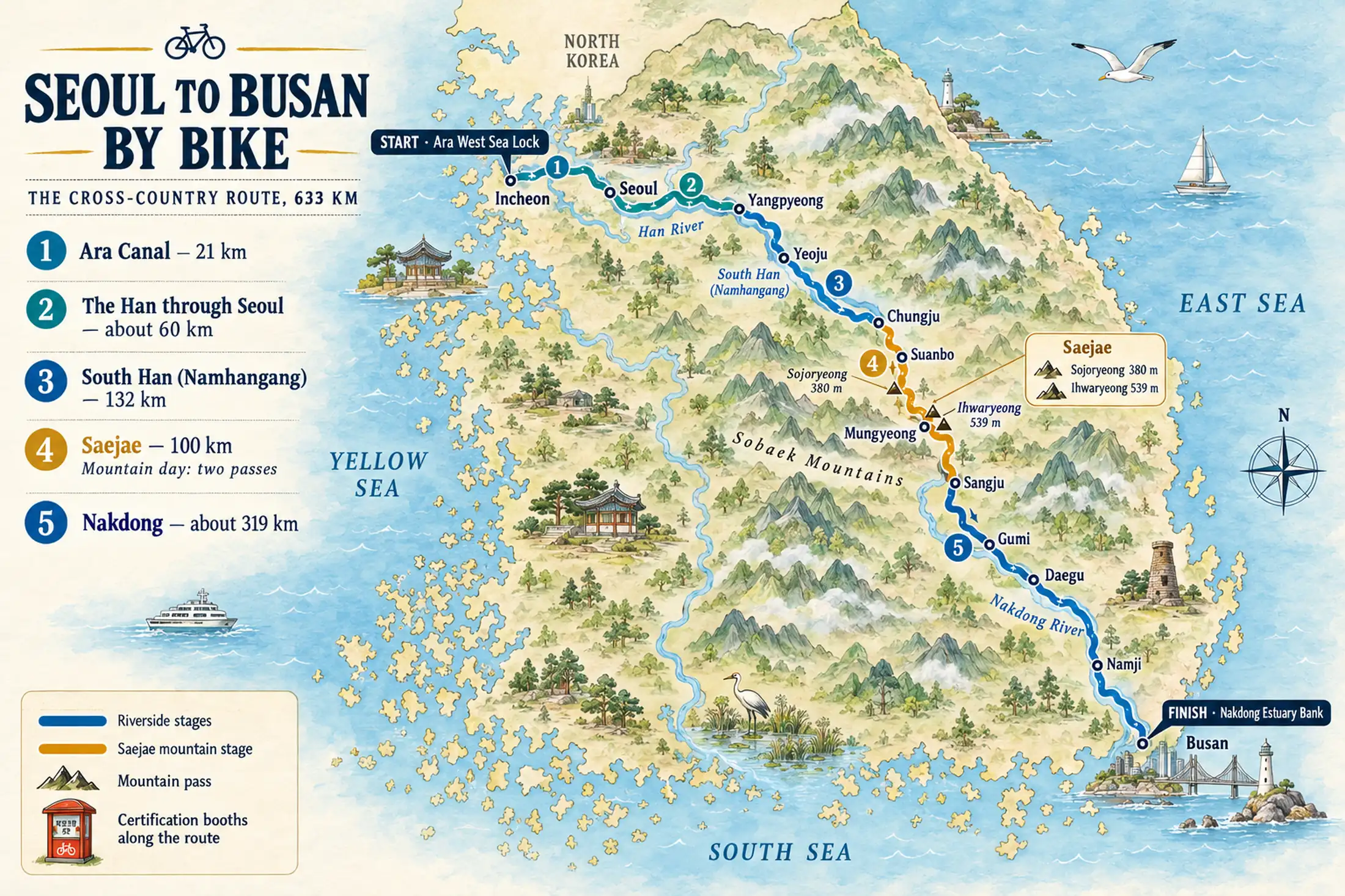

Most riders go north to south. You start where the canal meets the sea, buy your stamp passport at the first certification centre, and finish at the sea again in Busan.
What the riding is like
Mostly, it is the steady following of water. You ride embankment paths where the main sounds are your tyres and the river. The red certification booths come up every so often, like punctuation, and one watershed slowly hands over to the next. Through Seoul and the bigger towns the path runs through riverside parks, shared with walkers. Beyond them it is quieter, and some embankment stretches are a long way from the next village.

It is a route about rhythm and distance rather than drama, with one exception. The Saejae section crosses two passes in quick succession. Riding south, Sojoryeong comes first: a climb of about 140 metres over 2.3 kilometres, to 380 metres. Then comes Ihwaryeong, at 539 metres the longest and highest climb on Korea’s certification paths: about 310 metres of climbing over roughly 5 kilometres, averaging over 6%. On a loaded touring bike it is hard work but not technical, and the country around Mungyeong is some of the prettiest on the ride. The reward is a long descent to the Nakdong.
Older accounts give Ihwaryeong as 530 to 550 metres high with a climb of about 7 kilometres. Treat it as one substantial mountain day and plan it as your shortest day. The rest of the route is nowhere near as hard, but it is not dead flat either.
The stages
The route is made of four official bike paths, and the table splits the Han path into its Seoul and South Han parts. These are geographic stages, not days: the Nakdong alone is two or three days’ riding.
| Stage | From → to | Distance | Character and effort | Services / overnight | Main constraint |
|---|---|---|---|---|---|
| 1 Ara Canal | Ara West Sea Lock, Incheon → the Han at Seoul’s western edge | 21 km | Flat canal-side path | Incheon; Seoul | Buy the passport at the start |
| 2 The Han through Seoul | Seoul’s western edge → the city’s eastern side | About 60 km | Flat riverside parks | Seoul | Shared with walkers through the city |
| 3 South Han | East of Seoul → Chungju Dam | 132 km | A gentle climb up the river | Yangpyeong; Yeoju; Chungju | A long section: break it at a town |
| 4 Saejae | Chungju → Sangju | 100 km | Two passes: Sojoryeong, 380 m, and Ihwaryeong, 539 m | Suanbo; Mungyeong; Sangju | The mountain day: low gears, water for the climbs |
| 5 Nakdong | Sangju → Nakdong Estuary Bank, Busan | About 319 km | Flat riverside, long and steady | Gumi; Daegu; river towns; Busan | Quiet stretches between towns |
Section lengths from Korea by Bike’s route pages, read 1 October 2026. The Seoul figure is the 192 km Hangang path less its 132 km South Han part, and the Nakdong figure is the 389 km Nakdong path less the 70 km above Sangju. Both are our arithmetic; together the stages make about 633 km.
A five- to seven-day shape
One recent guide suggests six days at about 100 kilometres a day, seven or eight for first-timers, and four or five for fit riders. A common pattern is one day from Incheon through Seoul and one up the South Han to Chungju. The Saejae gets its own shorter day, and the Nakdong takes two or three. Stop in the towns rather than between them, because beds and food are there.

Planning the ride
An e-bike opens the route to far more riders. But since July 2026 Korail has barred e-bikes and other lithium-battery mobility devices from its trains, the KTX included, according to Cycling Korea’s summary of Korail’s notices. If you hire an e-bike, arrange a one-way hire with collection in Busan, and check the current rule with Korail before you rely on a train.
The bike, and getting back
You can bring your own bike, but many visitors hire one. Several Seoul-based shops specialise in one-way hire for this route: they deliver a bike in the Seoul area and collect it in Busan, which solves the return. Riders have reported a drop-off fee of around US$100; we could not confirm a current figure, so ask when you book. Book ahead in spring and autumn.
The KTX from Busan to Seoul takes about two and a half hours. It accepts a bike only if it is a folded folding bike, or taken apart and packed in a dedicated bag. There is no roll-on space. Korail’s commuter trains generally take full-size bikes at weekends and on public holidays. Decide how you and the bike are getting back before you set off, not in Busan.
The stamp passport and the medal
Korea turns the ride into a stamp rally. You buy a small certification passport for ₩4,000 at a staffed certification centre; the Ara West Sea Lock, at the start, is the obvious one. Then you stamp it yourself in the red booths along the path. Finish the route and you can claim a certificate, and buy a medal. It is optional and a little kitsch, and most riders end up loving it.

Bring won in cash: riders report that foreign cards often fail at certification centres.
The certificate is the reward most riders want, and the medal is the souvenir. It is bought separately once you finish. Its price is widely quoted, but we could not confirm it, and riders report that the medal shop wants a Korean address and payment. Ask at the finish, or at your hotel, before you fly home.
Beds, food and water
The towns along the route have cheap motels and pensions, and Seoul and Busan have proper hotels. Book ahead at weekends and in the autumn foliage season. Convenience stores are frequent enough to resupply on the move, but carry water and food into the quiet embankment stretches and over the Saejae passes. For maps, use Naver or Kakao rather than Google; our guide to staying connected in Korea covers data and apps.
When to ride
Spring, April to June, brings blossom and mild air. Autumn, September to November, is the classic window: cool, clear, and lit by the foliage the hills are famous for. Summer is hot and humid, with the jangma monsoon rains and the occasional typhoon. Winter is cold and can be icy on shaded riverside sections. Our guide to the best time to visit South Korea covers the seasons in more detail.
If the ride breaks down
The route runs close to the rail network, and towns such as Chungju, Gumi and Daegu have stations. If you run out of time or energy, you can leave by train and rejoin another day. The bike has to travel too: bagged on the KTX, or on a commuter train at the weekend. An e-bike cannot go on the train at all, so a hired e-bike has to go back through the hire company.
On the Saejae section, decide at Chungju or Suanbo whether you are fit for both passes that day, and stop for the night rather than start the climbs late. On the quiet Nakdong stretches, do not count on the next village for water. In an emergency, call 119 for an ambulance, or 112 for the police.
From what we have read, this ride is less about fitness than logistics: book a one-way hire with collection in Busan, and the rest is pedalling.
— Andrew + MargaretA final word on Seoul to Busan
Few countries have built anything like this: a whole nation crossed on a bike path, with a stamp waiting every few hours. Sort the bike and the way back before you start, give the Saejae its own day, and let the rivers set the pace.
Andrew + Margaret
- Cycling journeys Journeys
- Best cycling routes in South Korea Decide
- Can I cycle in South Korea? Practical
- Getting around South Korea Practical
- Busan Overview
- Visiting South Korea Overview
- Korea’s bike-path portal: routes and certification Official
- Korail: trains and carriage rules Official
- Cycling Korea: taking bikes on Korean trains Practical
- Korea by Bike: route-by-route detail Practical
Is this the Four Rivers trail?
Not quite. Korea’s certified network is often called the Four Rivers trail, after the Han, Nakdong, Geum and Yeongsan. The Seoul to Busan ride is the Cross-Country Route: the diagonal along the Han and the Nakdong, joined by the Saejae section. It uses two of the four rivers.
Can I ride it from Busan to Seoul?
Yes; the path and the stamps work either way. Riding north, the Saejae climbs change: Sojoryeong becomes a gentler 151 metres over 6.2 kilometres, and Ihwaryeong 305 metres over 5.3 kilometres. Most riders still go south and finish at the sea.
Do I have to collect the stamps?
No. The passport is optional, and you can ride the path without it. You need the stamps only for the certificate, though most riders find they give the days a rhythm.
Can I ride just part of it?
Yes. Towns with rail stations, such as Chungju, Gumi and Daegu, let you start or stop part-way, as long as the bike can travel on the train: bagged on the KTX, or on a commuter train at the weekend.