Christchurch
The South Island’s gateway: a garden city on the Avon, rebuilt after the earthquakes, with the hills, the sea and the Southern Alps all within reach
Christchurch is a city that has had to decide what it wants to be, and the answer is worth seeing. The earthquakes of 2010 and 2011 brought down most of its centre. What stands there now is new: low, bright buildings along a river that has been given back to people, food halls and laneways, a covered stadium, and a memorial that sits quietly by the water. Around it the older city endures. Punts drift under the willows, the Botanic Gardens blaze in autumn, and the bare gold Port Hills rise to the south. Most visitors arrive here and leave quickly for the mountains. Give it two days first; it will send you on your way knowing the South Island better.
What is ours, and what is researched. This page is not written from our own visit. Everything on it comes from the city council, Christchurch’s official visitor site, the museum, the transport operators and the other sources named at the foot of the page, checked on 29 September 2026. Where something is uncertain or changing, we say so. We will update the page when we go.
Last updated 29 September 2026
A little background
Long before the city, the river had a name. The Ōtākaro, which the settlers called the Avon, wound through swamp and grassland to the sea, rich in eels and birds. Waitaha, Ngāti Māmoe and then Ngāi Tahu gathered food along it, and Puari pā stood on its banks near today’s centre. Ōtautahi, the Māori name now used for the whole city, first belonged to one place on the river: the seasonal settlement of Tautahi, a Ngāi Tahu chief from Koukourarata, on the harbour now called Port Levy.
The city itself was planned in England. The Canterbury Association, a Church of England venture, sent out its first four ships in 1850. They reached Lyttelton that December, and the settlers climbed the Bridle Path over the Port Hills to see the plain they had bought. They laid out a grid of streets named after Anglican bishoprics, many of them Irish, such as Tuam, Cashel and Armagh, and in 1856 Christchurch became New Zealand’s first city. For a century and a half it wore the look of an English cathedral town, with stone Gothic buildings, a cathedral in the square and a river lined with willows.
Then the ground moved. A magnitude 7.1 earthquake on 4 September 2010 damaged the city but killed no one. At 12.51pm on 22 February 2011 a shallower quake struck close to the city, and 185 people died, more than 130 of them in two collapsed office buildings. The central city stayed behind a cordon until June 2013. Most of its buildings were demolished, and more than 8,000 homes on unstable land, most of them along the lower Avon, were bought out by the government and cleared.
People who lived through it will tell you the rebuild has been slow, contested and unfinished, and that it is theirs. It has also produced something unusual: a city centre designed afresh in the 21st century, with the river at its heart. The empty red zone along the Avon is now the Ōtākaro Avon River Corridor, being returned to wetland, forest and trail. The cathedral in the square is still fenced, and work on it is due to restart in 2026. Visitors come to Christchurch today to see a city that chose to begin again. See our guide to understanding Māori New Zealand for more on the iwi of this island.
How Christchurch fits together
Christchurch is flat, and it is built around a park. The centre is a neat grid inside four avenues, Bealey, Fitzgerald, Moorhouse and Deans, and the great green space of Hagley Park fills its western side. The Avon winds through both, then loops away north-east to the sea. Suburbs spread in every direction across the Canterbury Plains; the Southern Alps stand far off on the western horizon.
Two landmarks stop the spread. To the east is the sea, with long surf beaches running up the coast. To the south the Port Hills rise abruptly, the eroded rim of an ancient volcano, and behind them lies Lyttelton Harbour in the flooded crater. The airport is out on the plain, 12 km to the north-west. Most first visits are spent within a short walk of Hagley Park; the five areas below cover the choices, and our guide to where to stay in Christchurch compares them and names places to look.
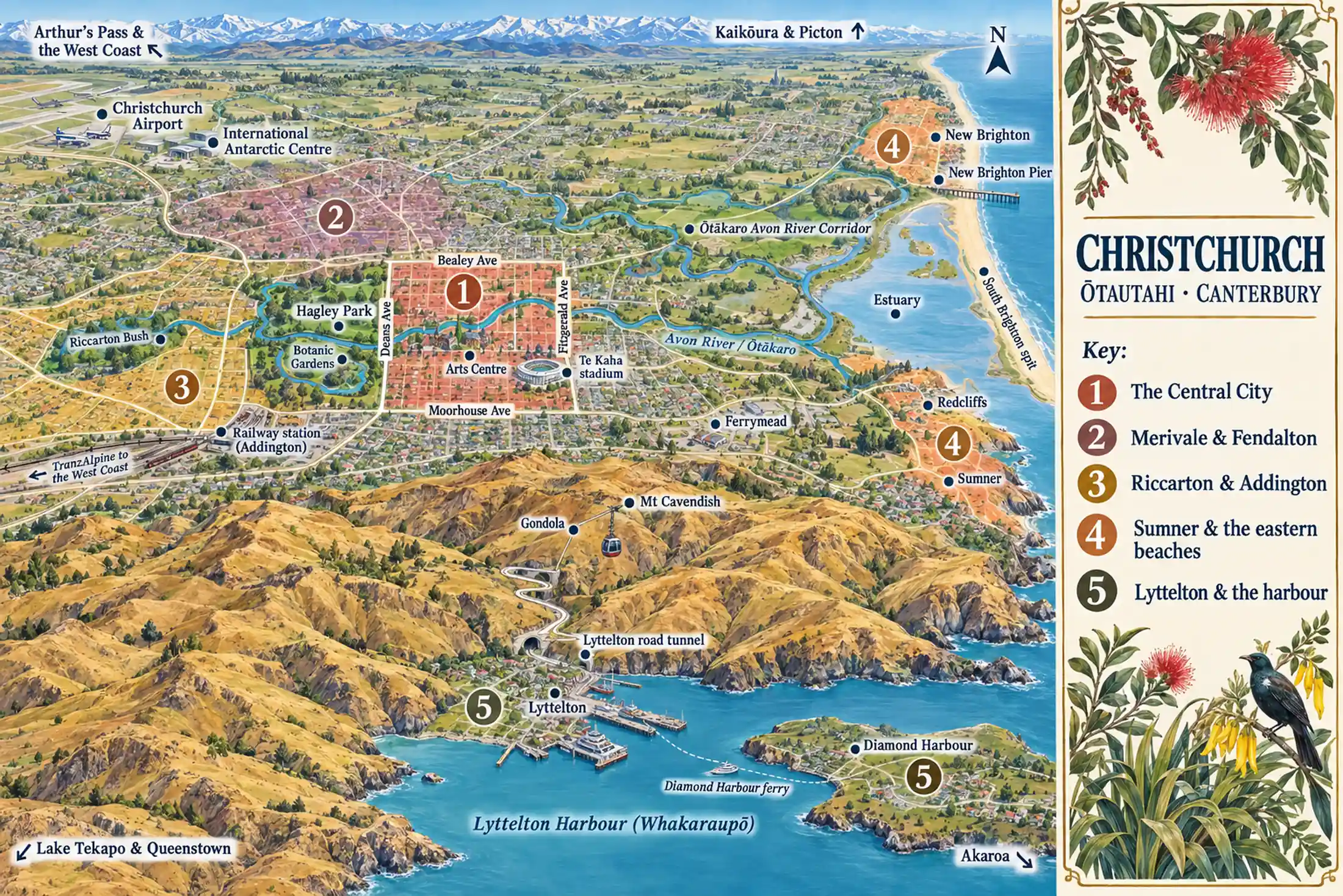
The Central City
inside the Four AvenuesThe square mile inside Bealey, Fitzgerald, Moorhouse and Deans avenues, with Hagley Park filling its western side. Almost everything a first-time visitor comes for is here or a short walk away: the gardens, the river, the museums, the tram and the food precincts.
Merivale & Fendalton
leafy and residentialOld villas and big gardens on the north side of the park, with Merivale’s shopping streets at their heart. Close enough to walk into the centre through Hagley Park, and calmer at night.
Riccarton & Addington
the western sideRiccarton Road is lined with motels, and the railway station for the TranzAlpine is in Addington. Riccarton Bush, a fragment of the forest that once covered the plains, is a quiet surprise among the suburbs.
Sumner & the eastern beaches
the city’s seasideSumner is a seaside village where the Port Hills meet the sea, with Redcliffs beside it and New Brighton’s long beach and pier to the north. Stay here if you would rather hear the waves than the city.
Lyttelton & the harbour
over the hillOver the Port Hills, Lyttelton climbs steeply above its working port. The first settlers landed here in 1850. A ferry crosses the harbour to Diamond Harbour. Lovely to stay in, if you have a car or do not mind the bus.
Places you don’t want to miss
Six places, three in the city and three on its edges. Together they tell Christchurch’s story: the English garden city, the city of the earthquakes, the volcano it sits against, and the ice beyond the horizon.
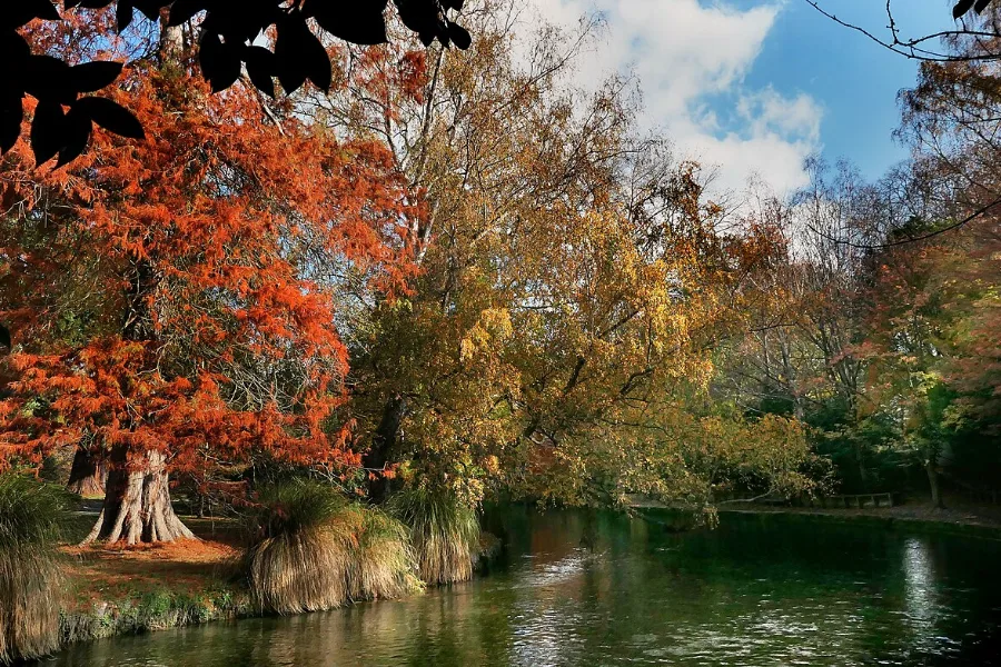
The Botanic Gardens, Hagley Park and the Avon
The green heart of the city, and free. The Botanic Gardens, founded in 1863, sit in a loop of the Avon inside 165 hectares of park, with a rose garden, glasshouses and old English trees that blaze in autumn. Take a punt from the Antigua Boat Sheds and let someone else do the poling.
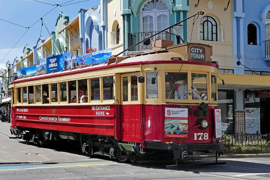
The rebuilt city centre
Walk it to understand what happened here, and what the city chose to become. Quake City tells the story of the earthquakes; the Transitional (Cardboard) Cathedral and the memorial wall on the Avon speak to it quietly. The Art Gallery is free, and the heritage tram links it all.
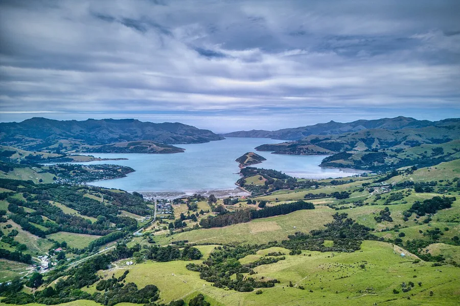
Akaroa and Banks Peninsula
An hour and a half south-east, the road climbs over an old volcano and drops to a harbour of astonishing blue. Akaroa was settled by the French in 1840 and keeps their street names. Out on the water live Hector’s dolphins, found only in New Zealand.
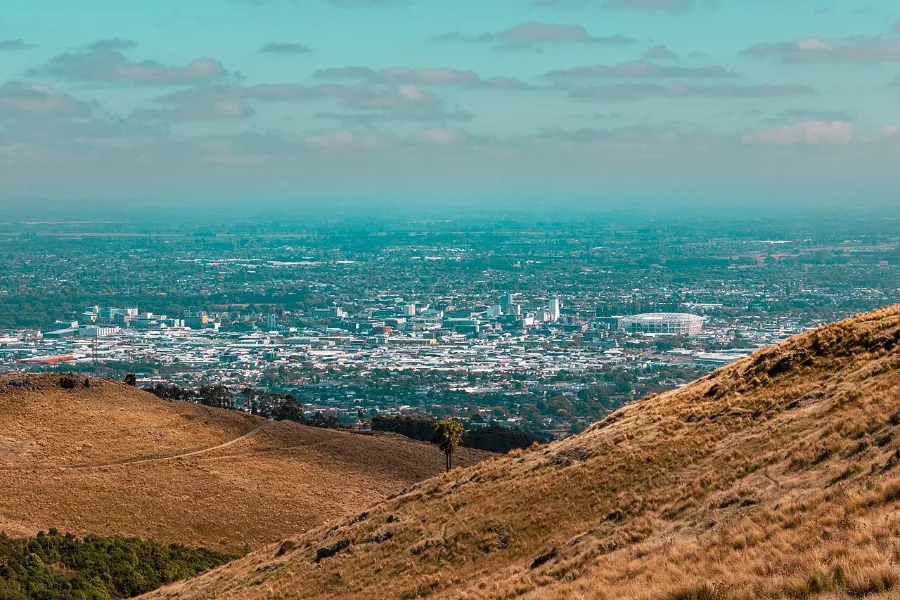
The Port Hills and the Gondola
The bare, golden hills on the city’s southern edge are the rim of an ancient volcano. The Gondola lifts you from the Heathcote Valley to the crest in about ten minutes. On one side the whole city lies flat on the plains; on the other, Lyttelton Harbour fills the crater.

The International Antarctic Centre
Christchurch is one of the world’s gateways to Antarctica: expeditions fly south from the airport next door. The centre lets you step into a polar storm, ride in an all-terrain Hägglund and meet little blue penguins. A good choice for families, and for a rainy day.
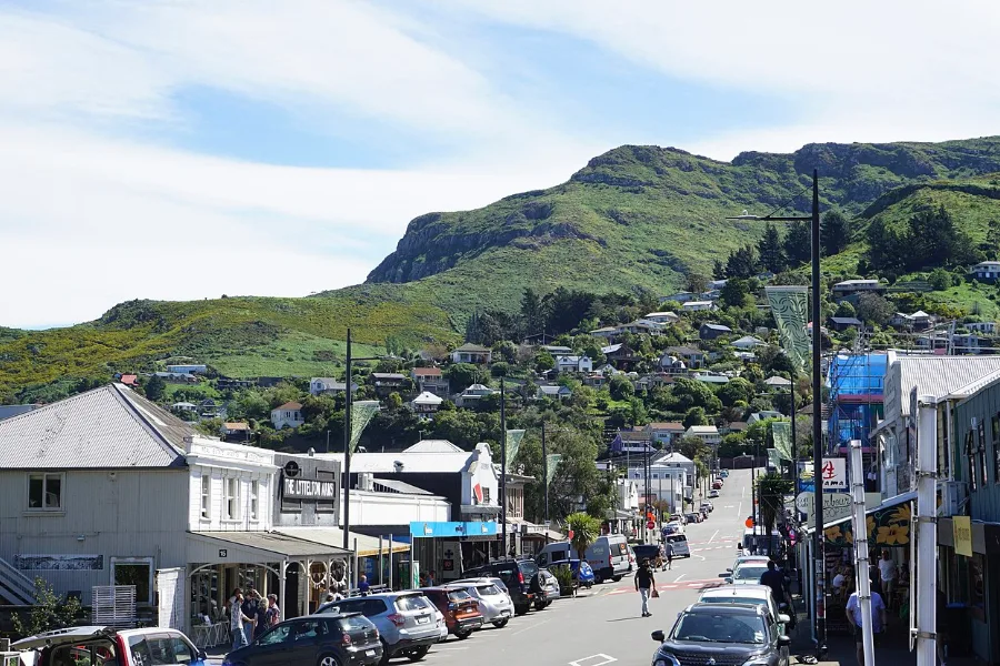
Lyttelton and the harbour
Through the tunnel, twenty minutes away, the city’s port town tumbles down the crater wall to the water. Come on a Saturday morning for the farmers’ market, take the little ferry across to Diamond Harbour, or walk the Bridle Path the first settlers climbed in 1850.
The four practical questions
When should I visit Christchurch?
Warm, dry summers, golden autumns, and crisp winter days with snow on the Alps.
See below ↓ Where to stayWhere should I stay in Christchurch?
Five areas compared, and the places we would look in each.
Read the guide → Where to eatWhere should I eat in Christchurch?
Market halls, Riccarton Road’s noodles, Canterbury wine and a food day.
Read the guide → Getting aroundHow will I get around Christchurch?
A walkable centre, the buses, the airport link, and a city made for cycling.
See below ↓When to visit
November to April is the season to aim for, with the long, warm days of summer and a golden autumn in March and April, when Hagley Park and the Botanic Gardens are at their finest. Christchurch is one of New Zealand’s drier cities, with about 620 mm of rain in a year and plenty of sun. Winter is cold, frosty and often clear, and it has its own appeal: snow on the Alps, fewer visitors, and the ski fields within reach.
| Months | By day | What it means |
|---|---|---|
| December to February | About 22°C, sometimes over 30°C in a nor’wester | Warm and long-lit; the busiest months |
| March to May | About 20°C, falling to 14°C | Settled, with autumn colour in the parks |
| June to August | About 11°C, with frosty nights | Crisp and quiet; snow on the Alps |
| September to November | About 15°C, rising to 19°C | Blossom and spring bulbs; changeable |
Watch for the nor’wester, the hot, dry wind that pours off the Alps across the plains, and for the cool easterly sea breeze that often sets in on summer afternoons. Pack a layer in any month. Our guide to the best time to visit New Zealand sets Christchurch in the national picture.
Getting around
The centre is compact and flat, and you can walk almost everywhere in it. For the rest of the city, Christchurch has buses and no suburban trains. Most routes meet at the Bus Interchange on Lichfield Street, and the Metro website plans journeys. Since November 2025 you can pay with a contactless bank card or phone: a flat $3 on the bus and $5 on the Diamond Harbour ferry. From 23 November 2026 the old Metrocard and cash will no longer be accepted, so plan to tap a card.
From the airport, buses 8 and 29 run to the centre in about 30 minutes; the 8 runs every 15 minutes on weekdays and the 29 every 30. A taxi or rideshare takes 20 to 30 minutes. The heritage tram is a lovely way to see the centre, a hop-on, hop-off loop of about 50 minutes with 18 stops, but it is a sightseeing ride, not transport.
Christchurch may be the easiest city in New Zealand to cycle. It is flat, and a network of major cycle routes runs into the centre. Hire bikes and e-scooters are easy to find. See cycling in Christchurch. For Akaroa, the Port Hills and the day trips below, a car is simplest; our guide to getting around New Zealand covers hire cars, trains and flights onward.
Day trips
Christchurch is a base as much as a destination, and some of the South Island’s best days start here. Akaroa and Banks Peninsula, about 1 hour 25 minutes away, are the classic first choice, and our Akaroa guide covers them in full.
The TranzAlpine is the other. The train runs from Addington station across the plains, up the gorges of the Waimakariri and over the Southern Alps to Greymouth. You can ride as far as Arthur’s Pass, walk in the mountains, and come back the same day; by road Arthur’s Pass is about two hours. The train’s running days change with the season, so check before you plan.
Hanmer Springs, about 1 hour 45 minutes north, is an alpine village with hot pools in the mountains. Waipara, under an hour north, is Canterbury’s wine valley, known for pinot noir and riesling. Kaikōura, famous for whales, is about 2 hours 20 minutes up the coast; it is better as a night on your way north than a day out. Our guide to day trips from Christchurch compares them all, and says which are better as a night away.
Drive times are planning estimates in normal conditions, checked on 29 September 2026.
A few honest limits
Some of the city’s great buildings are still closed. Canterbury Museum is being strengthened and redeveloped, with reopening expected in about 2029; until then a small pop-up museum is open on Gloucester Street, and the museum’s Quake City is open on Durham Street. Christ Church Cathedral, in the square, is closed. Work on it stopped in 2024 and is due to restart in 2026, and its project says the nave could be open by the end of 2030. The Gothic Arts Centre has reopened in stages, but parts are still being restored.
The rebuild is not finished either. You will still see empty lots and car parks between the new buildings. And Christchurch is quieter after dark than Auckland or Wellington: its evenings are about dinner, a bar by the river or a show, rather than a late night out. Our guide to Christchurch nightlife sets out where.
Christchurch in books. The crime novelist Ngaio Marsh lived nearly all her life in the city, and her house in the Cashmere hills is kept as a heritage house; check its opening before you go. Margaret Mahy, the children’s author, is remembered in the Margaret Mahy Family Playground by the Avon, as much fun as she was. The city once marked its writers with a trail of plaques; we could not confirm how many survived the earthquakes.
Ride the Gondola to the top of the Port Hills late on a clear afternoon and walk a few steps from the station along the crest. The tussock is gold and dry, and the wind carries its dusty smell. Turn north: the whole city lies flat below you, a green carpet stitched with streets, running out to the long pale line of the Alps far to the west. Turn south: Lyttelton Harbour lies in the crater, deep blue, ships at the wharves, Banks Peninsula folding away behind. In the space of a few steps you see both what the settlers came for and what the volcano left. Stay until the light goes amber on the plains.
A final word on Christchurch
Most travellers pass through Christchurch on their way to somewhere else. Stop for two days and you will see a city that has lived through something few cities do, and has quietly remade itself around a river and a park. Walk in the gardens, take a punt, stand by the memorial, ride up the hills at dusk. Then go to the mountains. You will understand the South Island a little better for having started here.
Andrew + Margaret
- Visiting New Zealand Overview
- Where to stay in Christchurch Practical
- Where to eat in Christchurch Practical
- South Island itinerary Journeys
- New Zealand in three weeks Journeys
- New Zealand in two weeks Journeys
- Getting around New Zealand Practical
- The best time to visit New Zealand Practical
- Can I cycle in New Zealand? Practical
- Queenstown Overview
- Wellington Overview
- Understanding Māori New Zealand Culture
- ChristchurchNZ — the official visitor site Official
- Metro — buses, the ferry and fares Transport
- Canterbury Museum — Quake City and the pop-up museum Official
- Christchurch Botanic Gardens Official
- Great Journeys NZ — the TranzAlpine Booking
- NZ History — the February 2011 earthquake History
- Ngaio Marsh, Black Beech and Honeydew (1965), her autobiography of a Christchurch life Reading
Is Christchurch worth visiting after the earthquakes?
Yes. The centre has been rebuilt around the river, the gardens and Hagley Park were never lost, and the story of the earthquakes and the rebuild is itself one of the reasons to come. A few major buildings, the museum and the cathedral among them, are still closed.
How many days do I need in Christchurch?
Two full days for the city, and a third or fourth for Akaroa or the TranzAlpine. Many South Island routes, ours included, spend a night or two here at the start and at the end.
How do I get from Christchurch Airport to the city?
Buses 8 and 29 run to the centre in about 30 minutes; pay with a contactless card. A taxi or rideshare takes 20 to 30 minutes.