Cairns
A working tropical city that is mostly a doorway — and a good one
Nobody comes to Cairns for Cairns. They come for the reef, the rainforest and the islands, and Cairns is the place that makes all three reachable in a way nowhere else in Australia manages. Understanding that is the whole trick: judge it as a base and it is excellent, judge it as a destination and you will wonder what the fuss was about.
We have been to Cairns, and this page says where that helps and where it does not. We slept in the northern beaches, went out to the reef, and took the railway up to Kuranda and the cableway back down.
The visit is more than ten years old, so it is worth nothing for a recommendation about a hotel or a restaurant and a good deal for the shape of the place: where the city ends, how far the beaches are, what the light does, and the fact that we could not swim at the beach because of stingers while the reef trip ran perfectly well.
Last updated 20 September 2026
A little background
The city stands on Gimuy, the country of the Gimuy Walubara Yidinji people, with Yirrganydji country running up the coast to the north and Djabugay country over the range behind it. Cairns Regional Council acknowledges eleven traditional custodian groups across its region, which tells you something about how many distinct places are folded into what a visitor experiences as one destination.
The European town was a port before it was anything else — sugar and gold out, supplies in — and it kept that job for a century. What changed it was not a plan but a runway and a reef. International flights arrived, the Great Barrier Reef became a thing people crossed the world to see, and a working harbour town acquired a tourism industry roughly the size of itself.
The city's most-loved feature was built because of what it lacks. The Esplanade Lagoon opened in March 2003 — 4,800 square metres of lifeguarded saltwater on the waterfront, because Cairns has no swimmable city beach — and has had more than 25 million visits since. It is one of the best pieces of public space in tropical Australia, and it is free.
How the city fits together
Cairns is small, flat and legible. The centre sits on Trinity Inlet, and three things happen within about a kilometre of each other: the Esplanade along the water, the Marlin Marina where every reef boat leaves from, and the compact grid of streets behind them. If you are staying in the city you will walk to all of it, and you will not need a car for a single day of it.
The Esplanade is the city's front room. A boardwalk runs above the foreshore with the Lagoon at its southern end, and the whole walk is about five kilometres there and back. There are free barbecues, a skate plaza, playgrounds and volleyball courts, and in the evening the length of it fills with people doing very little in a pleasant climate.
It is also where the surprise is. The foreshore is not a beach. It is mudflat, exposed at low tide, and visitors who booked a tropical city on the strength of a photograph find that out on their first morning.
It was sand once: the Barron River shifted its mouth north in the 1930s and cut off the sand supply, and the mud has been advancing ever since. The city trucks sand in at Half Moon Bay and pulls out mangrove saplings to slow it. Nobody is hiding this, but nobody advertises it either, so we will: there is no beach in Cairns.
Edge Hill, a few minutes inland, is where the Botanic Gardens are — free, open daily, one of the best tropical plant collections in the country, with an Aboriginal Plant Use Garden, a conservatory, rainforest boardwalks and the Centenary Lakes. It is the one in-city thing we would tell you not to skip.
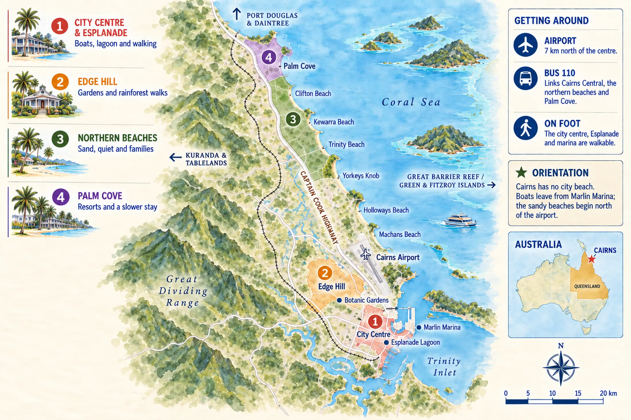
And then there are the northern beaches, which is where the sand actually is: a strip running from about 10 km to 25 km north of the centre, past the airport — Machans, Holloways, Yorkeys Knob, Trinity, Kewarra, Clifton and finally Palm Cove, which the regional tourism body puts at about thirty minutes by car. Quieter and greener than the city, and the trade is obvious: sand and calm against walkability and boats.
| Area | What it is | Suits | The trade |
|---|---|---|---|
| City centre and Esplanade | A compact grid behind a five-kilometre waterfront boardwalk, with the Lagoon at one end and the marina at the other | Anyone taking boats, and anyone who would rather not drive | No beach, and an evening that is busier than some people want |
| Edge Hill | A leafy inland suburb minutes from the centre, built around the Botanic Gardens | A quiet morning among tropical plants; walkers heading up the Mt Whitfield tracks | Not a base — a place you go to for half a day |
| Northern beaches, Machans to Clifton | A ribbon of low-key beach suburbs from 10 km to 23 km north, past the airport | Sand, quiet, and families who want to walk to the water | You drive or take route 110 for every boat, and the swimming depends on the season |
| Palm Cove | The polished end of the strip at about 25 km, a palm-lined beachfront of resorts and restaurants | A week that is mostly about not moving, with day trips bolted on | The furthest from the wharf, and priced accordingly |
The map below is the orientation, and the words are the equivalent of it: a compact centre on an inlet with no beach, an airport seven kilometres north of that centre, and a 25-kilometre ribbon of beach suburbs beyond the airport. Everything a visitor comes for is somewhere else again — out to sea, or up the range behind the city.
Places you don't want to miss
Almost everything worth the journey is reached from the city rather than found in it. These five are what people come for, and only the first has a page of ours behind it so far.

The Great Barrier Reef
The reason the city has an international airport. Which trip you choose matters more than which day you go, and our own page works through the four ways of reaching it.

Kuranda, by railway and cableway
37 kilometres of 1880s railway up to 327 metres through 15 tunnels, then a 7.5 kilometre cableway return over the canopy. We did that, and the train is the half we would keep.

The Daintree and Cape Tribulation
Rainforest running down to the sand with the reef beyond it, and the deepest branches of the plant family tree still growing in it. A long day from Cairns, across the river by cable ferry.

Green Island
A coral cay 27 kilometres offshore, 45 minutes by ferry from the wharf: rainforest in the middle, a lifeguard on the beach, and snorkelling straight off the sand. The gentlest way to see reef.

Fitzroy Island
Granite, hills and forest 25 kilometres east — a continental island that was part of the mainland before the sea rose. You go for the walking tracks and the snorkelling off the fringing reef.
Before you book the railway or the cableway, check both operators, and we mean this week rather than in general. Skyrail is running a reduced Kuranda-to-Barron-Falls loop only, Wednesday to Sunday, from 19 August to 25 October 2026 while the cableway is upgraded, boarding between 10am and 3.30pm, and it closes entirely on the Mondays and Tuesdays in between — 21 and 22 September, 28 and 29 September, and 5, 6, 12, 13, 19 and 20 October. Full Smithfield-to-Kuranda service is due back from late October.
The railway has been closed since 9 September, and only one of the two operators says so. Queensland Rail found a bridge defect during routine maintenance — it attributes it to a run of heavy wet seasons — and shut the Kuranda Range line, putting booked passengers onto free coaches. Skyrail's site published the cancellation; the railway's own site still carries no notice of it at all, and the Service Updates page its FAQ points you to does not exist. Queensland Rail's alerts feed would not load on either of the two days we checked. Reported end dates differ by a day, and neither operator has published a resumption notice, so telephone 1800 577 245 before you travel. Published fares in Australian dollars, checked 21 September 2026: railway $87 return in Heritage Class, Skyrail $111 return, the combination ticket $145.50, all quoted as valid to 31 March 2027. The Daintree River ferry is $57 return for a car.
The four practical questions
When should I visit Cairns?
The dry season and the stinger season decide this, and they are not the same thing.
See below ↓ Where to stayWhere should I stay in Cairns?
City centre against northern beaches — the trade is boats and walking against sand and quiet.
Read the guide → Where to eatWhere should I eat in Cairns?
The night markets, the esplanade strip and the places locals actually use.
Read the guide → Getting aroundHow will I get around?
Whether you need a car, and what the bus north to the beaches actually does.
See below ↓When to visit
Two seasons decide this, and they overlap awkwardly. The wet season brings the heat, the rain and the cyclone risk; the marine stinger season closes the sea for swimming. They are not the same months and neither is a reason to cancel a reef trip.
| Months | Weather | Sea | What it means |
|---|---|---|---|
| June to October | The dry. July averages 26°C by day and 33 mm of rain across the month | Outside stinger season | The best window, and the busiest. Beach swimming is on, and the reef is at its most reliable |
| November to December | Building heat and humidity | Stinger season begins | Netted enclosures and a stinger suit, or the Lagoon. Reef trips run normally |
| January to March | The wet. February averages 437 mm over 16 rain days, 31°C and 78% humidity at 9am | Stinger season, cyclone season | The hardest months. Rain comes in bursts rather than all day, but the heat is relentless |
| April to May | Drying out, still warm | Stinger season ends around May | Quieter, green, and good value before the dry-season crowds arrive |
What stinger season actually means
Two animals: the box jellyfish, dangerous and large, and the Irukandji, which is the size of a fingernail. Netted enclosures are the standard answer and they are not a complete one. Queensland Health's own guidance is that nets are very effective at keeping box jellyfish out and cannot keep Irukandji out, because the animal is small enough to pass through. Surf Life Saving's north Queensland manager put it plainly in 2023: the nets can never be one hundred per cent stinger-proof.
A full-body lycra or neoprene suit is described by the same guidance as the single best protection, covering around 75% of the body, and operators hand them out on reef trips as a matter of course. The Lagoon is the honest alternative — the council built it as a place to swim without stingers or crocodiles, and in stinger season that is exactly what it is for.
Getting around
For a city-only stay you do not need a car. The centre, the Esplanade, the Lagoon and the marina are within a short walk of one another, every reef and island boat leaves from the same wharf, and the airport is seven kilometres north — closer to the city than the beaches are.
The bus north is real public transport, not a tourist shuttle. TransLink route 110 runs between Cairns Central and Palm Cove by way of Smithfield, Trinity Beach, Kewarra and Clifton, and takes roughly 45 to 50 minutes end to end. If you are staying at the beaches and coming into town for a boat, that is your fallback when you would rather not drive.
You need a car for the days that matter most — the Tablelands, the Daintree, the waterfall circuit — unless you are taking a tour, and on those routes a tour is a perfectly reasonable answer. The one journey where the vehicle is the point is Kuranda, and you would not drive that anyway.
Cairns Airport publishes no distance or transfer time to the city or to the beaches, so treat any figure you are quoted for an airport transfer as the operator's own.
Day trips
Kuranda and the Daintree are above, with the highlights, because they are what people come to this part of Queensland for. These are the other days — good ones, but the second rank. Two of them are straightforward: Mossman Gorge, the easiest rainforest walk from here, and the Atherton Tablelands, where you can swim in a crater lake sixty-five metres deep. Two ask a great deal more of you: the waterfall circuit, three falls on one loop, and Mission Beach, for the cassowaries and the almost-empty island off it.
Port Douglas is the one to sleep at rather than drive to. An hour or so north on the coast road, with Four Mile Beach along its edge and a Sunday market — and a day return spends the best of it on the highway. We went out to the reef from Port Douglas ourselves, and it is a different day from the Cairns version.
All five, with the driving times, the road conditions and what each day actually costs you in daylight, are on our day trips from Cairns page.
A few honest limits
The sea is closed to casual swimming for half the year. Roughly November to May, and no amount of planning changes it. It does not stop the reef trips, which supply stinger suits, and it does not stop the Lagoon.
Cairns is not a beautiful city. It is a working port with a tourist strip attached, and people who arrive expecting a tropical Noosa are disappointed by the first evening. What it has instead is proximity: nowhere else puts a coral reef, a rainforest, a set of islands and a tableland within a day of the same bed.
Stand on the Esplanade boardwalk at low tide, early, before the heat arrives. The water has gone and what is left smells of warm mud and mangrove — a thick, low, green smell that is nothing like the sea. Listen for the tick and pop of the flats as they drain, and watch the waders working across them. This is what the coast here actually is, and once you have stood in it for ten minutes, the absence of a beach stops feeling like something missing.
A final word on Cairns
Give it four days and treat it as a doorway and Cairns is one of the great bases in Australia — reef one day, rainforest the next, an island after that, and a spare day held back for the weather, which you will need. Give it two days and judge it as a city and you will wonder why anyone bothered. The town is not the point, and it has never pretended otherwise.
Andrew + Margaret
- The Great Barrier Reef from Cairns Highlight
- Green Island Highlight
- Fitzroy Island Highlight
- The Daintree and Cape Tribulation Highlight
- Kuranda, by railway and cableway Highlight
- Day trips from Cairns Highlight
- Where to stay in Cairns Practical
- Where to eat in Cairns Practical
- Best time to visit Australia Practical
- Entry requirements for Australia Practical
- Visiting Australia Overview