Hawke's Bay Trails
About 180 to 200 kilometres of easy riding between the sea, the rivers and the vineyards
The Hawke’s Bay Trails are an easy-going Great Ride: not one long journey but a web of flat, well-surfaced paths spreading out from Napier and Hastings, along the Pacific shore, up the river stopbanks and out among the cellar doors. You can ride an hour along the seafront or three days across the whole network, and almost all of it is graded Easiest or Easy; only the Tuki Tuki Loop and parts of the Napier Loop are harder. It is the ride for anyone who has never done a Great Ride, and a fine one for anyone who has. It is one of the twenty-three Great Rides we compare in our guide to the best cycling routes in New Zealand.
How this page was madeWe have not ridden the Hawke’s Bay Trails. This is a researched route guide, from Hawke’s Bay Trails, the New Zealand Cycle Trail and the Hawke’s Bay Regional Council, checked on the date below. Where the official sources disagree we say so. When we ride it, we will say so here.
Last updated 29 September 2026
The route
The trails are a network, not a line, and the best way to understand them is as three families of rides. Hawke’s Bay Regional Council groups them the same way.
The Water rides start in Napier. They follow Marine Parade and the coast, circle the Ahuriri Estuary and run inland along the Tūtaekurī River stopbanks to Taradale and Puketapu. Much of it is on concrete, and it begins in the town itself.
The Wineries rides run south of Napier across the Heretaunga Plains, from Clive through the Gimblett Gravels and the vineyards west of Hastings. They are flat, mostly lime sand, and lined with cellar doors; our guide to Hawke’s Bay wine country covers what to taste.
The Landscapes rides go south and east from Clive and Havelock North: along the coast to Clifton, facing Cape Kidnappers, and up the Tukituki River below Te Mata Peak. Here the network is at its most scenic, and on the Tuki Tuki Loop at its hardest.
There is no set direction and no single start. Stay in Napier for the Water rides, and ride out along the coast to Clive for the others. Stay in Havelock North if the vineyards and the Tukituki are the point; our guide to where to stay compares the two. The official interactive map on the Hawke’s Bay Trails website shows every ride and its current detours.
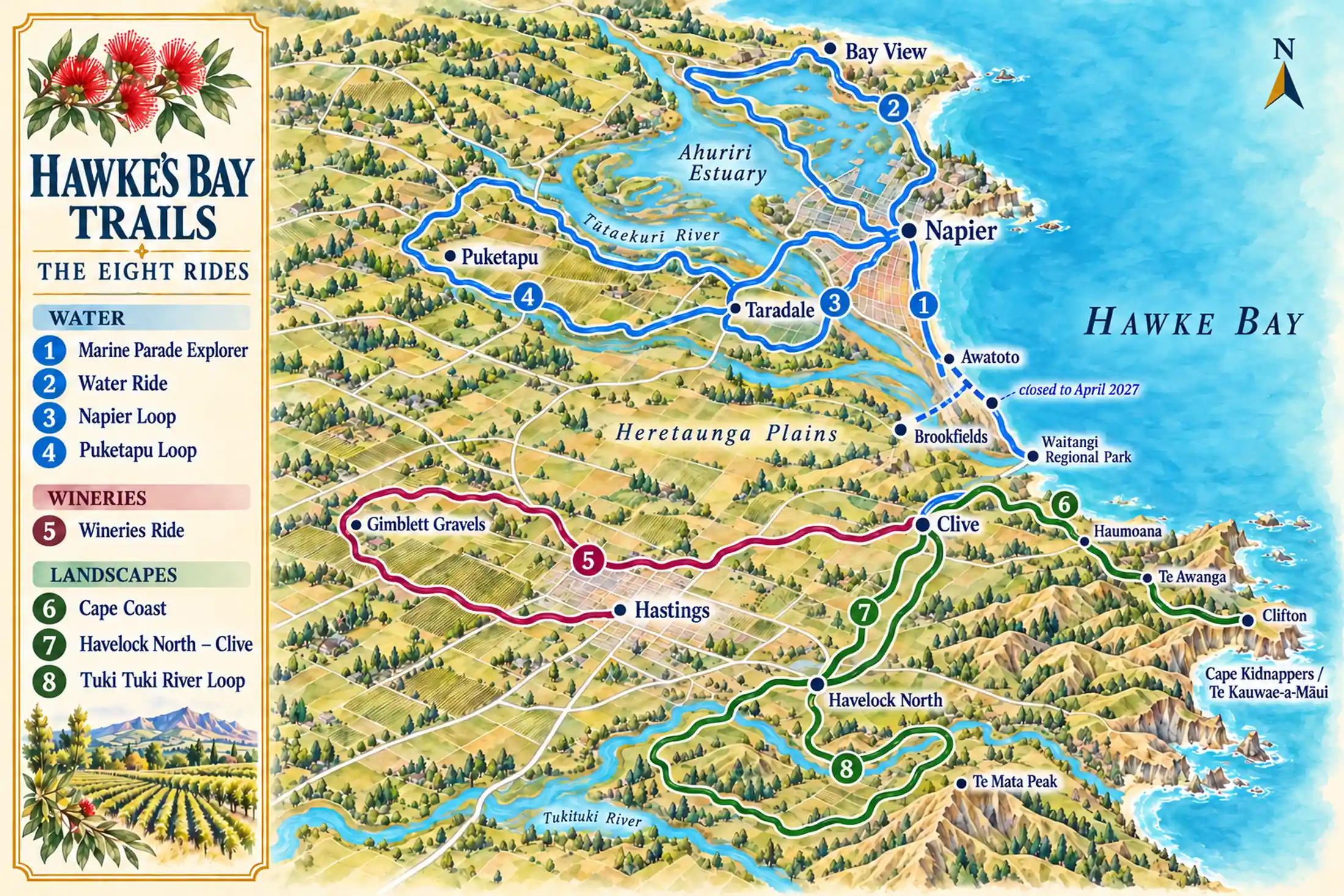
In words: the blue Water rides spread from Napier, north round the estuary to Bay View, south along the coast and inland along the Tūtaekurī to Taradale and Puketapu. Clive, on the coast south of Napier, is the hinge of the network: the red Wineries Ride runs west from it past Hastings to the Gimblett Gravels, and the green Landscapes rides run east along the coast to Clifton and south to Havelock North, where the Tuki Tuki Loop begins.
What the riding is like
Easy, above all. Most of the network is graded 1 or 2 on the New Zealand Cycle Trail scale, Easiest and Easy, on wide paths of compacted lime sand or concrete with few hills. The official descriptions promise wetlands and bird hides on the Ahuriri Estuary, stopbank riding along the Tūtaekurī and Tukituki rivers, Oak Avenue among the vineyards, and views of Cape Kidnappers from the coast.
The ease has two limits. The network crosses and briefly joins public roads, especially through the villages and on the Havelock North and Tuki Tuki rides, so it is not entirely traffic-free. And the Tuki Tuki Loop, the only ride graded 3, Intermediate, throughout, has hilly sections on Tukituki Road; the trails body recommends riding it anticlockwise. The Napier Loop is graded 1 to 3, so parts of it are harder too.
What makes the riding special is what you ride between: Napier’s Art Deco streets at one end of the day, a cellar door in the middle, a café in a coastal village at the other. Two sections, Marine Parade and the Ahuriri to Bay View path, are described as suitable for wheelchairs and hand-bikes.
On the Water Ride, stop at one of the bird hides on the estuary. Lean the bike outside, step in and sit for ten minutes without speaking. The trails body points riders to these hides on the estuary wetlands, and to remnants of the 1931 earthquake along the same ride. Let your breathing slow after the ride and listen first, before you look: what calls, what moves on the water, what the wind is doing to the reeds. Then look, and see how much you had been riding past.
The stages
Here the stages are the network’s eight named rides, numbered from Napier outwards. Distances are from Hawke’s Bay Trails; where the New Zealand Cycle Trail gives a different figure, the profiles say so.
| Stage | From → to | Distance / time | Character and effort | Services / overnight | Main constraint |
|---|---|---|---|---|---|
| 1 Marine Parade Explorer | Napier seafront → Waitangi Regional Park | 15 km one way; 30 km return | Grade 1; concrete and lime sand, little road | Napier; the National Aquarium on the way | Return the way you came |
| 2 Water Ride | From Napier around the Ahuriri Estuary, to Bay View | 35–76 km, by variant | Grade 1–2; concrete and lime sand | Napier and Ahuriri | Awatoto–Brookfields closed until April 2027 |
| 3 Napier Loop | Napier → Taradale → Napier | 38 km; 2–4 h | Grade 1–3; short road sections | Taradale | Tūtaekurī detours; check the alerts |
| 4 Puketapu Loop | Taradale area → Puketapu → back | 17 km; 1.5–3 h | Grade 1–2; lime sand | Puketapu village | Stay on the lime sand; stopbank closed |
| 5 Wineries Ride | Clive or Roys Hill → Gimblett Gravels and back | 30 km from Roys Hill; 60 km from Clive | Grade 1; flat, except the optional Roys Hill | Cellar doors along the way | Tasting and riding: spit or pace it |
| 6 Cape Coast | Clive → Clifton | 15 km one way | Grade 1–2; lime sand, brief road at Te Awanga | Haumoana and Te Awanga | East Clive works: short gate closures |
| 7 Havelock North–Clive | Havelock North → Clive | 18.5 km one way | Grade 1; road sections and lime sand | Havelock North | Road sections through the villages |
| 8 Tuki Tuki River Loop | Havelock North loop along the Tukituki | About 58 km | Grade 3; hilly road sections, crossings | Havelock North, start and finish | The only ride graded 3 throughout |
From Hawke’s Bay Trails and the New Zealand Cycle Trail, read 29 September 2026. Grades are the New Zealand Cycle Trail’s: 1 Easiest, 2 Easy, 3 Intermediate.
The Water Ride
The signature ride from Napier, and the most varied: seafront, port, the Ahuriri Estuary with its wetlands and bird hides, and remnants of the 1931 earthquake. Hawke’s Bay Trails gives it as 35 to 76 kilometres, depending on the variant, at Grade 1 to 2; the New Zealand Cycle Trail gives 35 kilometres at Grade 1. The 7 kilometres from Ahuriri to Bay View are concrete and suitable for wheelchairs.
The Wineries Ride
The best known of the rides: Grade 1 and, in Hawke’s Bay Tourism’s words, all flat except the optional climb of Roys Hill, through the vineyards west of Hastings past cellar doors such as Trinity Hill, Sileni and Unison, and along Oak Avenue. Start at Roys Hill Reserve for 30 kilometres, or at Clive for 60; the New Zealand Cycle Trail gives 36 to 47 kilometres. Bike hire bases sit on the ride itself, so you need not ride out from Napier.
Cape Coast and Havelock North to Clive
Two short rides that join the coast to the hills. The Cape Coast runs 15 kilometres from Clive to Clifton, through Haumoana and Te Awanga, with Cape Kidnappers ahead. Havelock North to Clive is 18.5 kilometres each way, with Te Mata Peak behind you and cellar doors such as Black Barn on the way.
The Tuki Tuki River Loop
The exception. About 58 kilometres from Havelock North, graded Intermediate, with road crossings and hilly sections on Tukituki Road, past Craggy Range and down the Moore Road descent, with the river and Te Mata Peak beside you. Ride it anticlockwise, as the trails body recommends, and only if you are comfortable on roads and hills.
Planning the ride
The Water Ride is the classic ride from Napier, but from 21 September 2026 until April 2027 the section between Awatoto and Brookfields is closed for stopbank work by the regional council. The detour runs via Johns Road and the Napier iWay to Marine Parade. Check the trails’ alerts page before you ride, as works elsewhere change often.
Bases and days
Most visitors ride the network as day rides from one or two bases rather than as a journey with a bag on the bike. A good pattern is three days: the Water rides from Napier, the Wineries Ride from a hire base on the trail, and the coast or the Tukituki from Havelock North. Our Napier guide covers the town and the region around it.
Bikes, e-bikes and shuttles
The New Zealand Cycle Trail says bikes can be hired in Napier, in Hastings and at smaller depots on the trails; ask the Napier i-SITE for the current hire and shuttle companies, and whether they deliver and collect. The New Zealand Cycle Trail advises booking shuttles ahead, especially from December to March. One practical detail from the trails body: a gate at Pakowhai Regional Park may be tight for larger e-bikes, and a concrete path is suggested instead.
Wine and the bike
On the Wineries Ride, spit at the cellar doors, pace the day, and buy to collect later rather than carry. Our wine country guide lists eight cellar doors with their hours.
Season
The trails are open all year, and the New Zealand Cycle Trail names December to March as the peak. The official safety page was unavailable when we checked, so we cannot give its advice on sun, wind and water; carry more water than you think you need on the open stopbanks and the coast, and check the trails’ website before you set out.
If the ride breaks down
Most of the network runs close to towns and villages: Napier, Taradale and Puketapu on the Water rides; Clive, Haumoana, Te Awanga and Hastings on the coast and the Wineries Ride; Havelock North at the start and finish of the Tuki Tuki Loop. If a rider tires, a bike fails or the weather turns, make for the nearest of these and call your hire company or a taxi; ask when you hire what help they offer, because it differs.
On the Tuki Tuki Loop, decide before you leave Havelock North whether you are fit for the hills, and turn back rather than press on if you are not. If a section is closed, follow the posted detour or turn back; do not ride a closed stopbank. For an emergency, call 111.
A final word on the Hawke’s Bay Trails
Most Great Rides ask something of you. This one mostly gives: flat miles by the sea, rivers under big skies, a glass at the end of the row. Ride the Water Ride from Napier, spend a day among the vineyards, and keep the Tukituki for when you want a challenge.
Andrew + Margaret
- Cycling journeys Journeys
- Best cycling routes in New Zealand Decide
- Can I cycle in New Zealand? Practical
- Napier Overview
- Hawke’s Bay wine country Highlight
- Art Deco Napier Highlight
- Where to stay in Napier Decide