Punakaiki
A village on the wild West Coast, beside the Pancake Rocks and Blowholes and the edge of Paparoa National Park
Punakaiki is a short strip of houses, motels and cafés on the coast road, and almost everyone who stops here comes for one thing: the Pancake Rocks, stacks of layered limestone where the sea booms through blowholes. Stay a night and you are more likely to be there when the tide is high and the blowholes are working, and you can add a walk into the limestone gorges and rainforest of Paparoa National Park behind. One night suits most journeys; two if you want the longer walks.
How this page was madeWe last travelled in the South Island before 2011, too long ago to describe Punakaiki from memory. So this page is researched from the Department of Conservation, the West Coast’s tourism body, Te Ara, GNS Science, the operators’ own pages and the sources named at the end, checked on 15 October 2026. Where they disagree, we say so. When we go back, we will say so here.
Last updated 15 October 2026
A little background
This stretch of coast belongs to Ngāti Waewae, a hapū of Ngāi Tahu, whose people lived and travelled here and traded pounamu. Today Ngāti Waewae is DOC’s partner at the rocks, and owns and runs the new visitor centre there. The meaning of the name Punakaiki is given in different ways, and we have not found an authoritative account; our guide to understanding Māori New Zealand gives the wider background.
The coast road between Westport and Greymouth was opened to vehicles in 1929, and the land behind the village became Paparoa National Park in 1987. Visitors to the rocks have grown fast: DOC’s figures show about 213,000 in 2008 and 511,000 in 2018.
How the place fits together
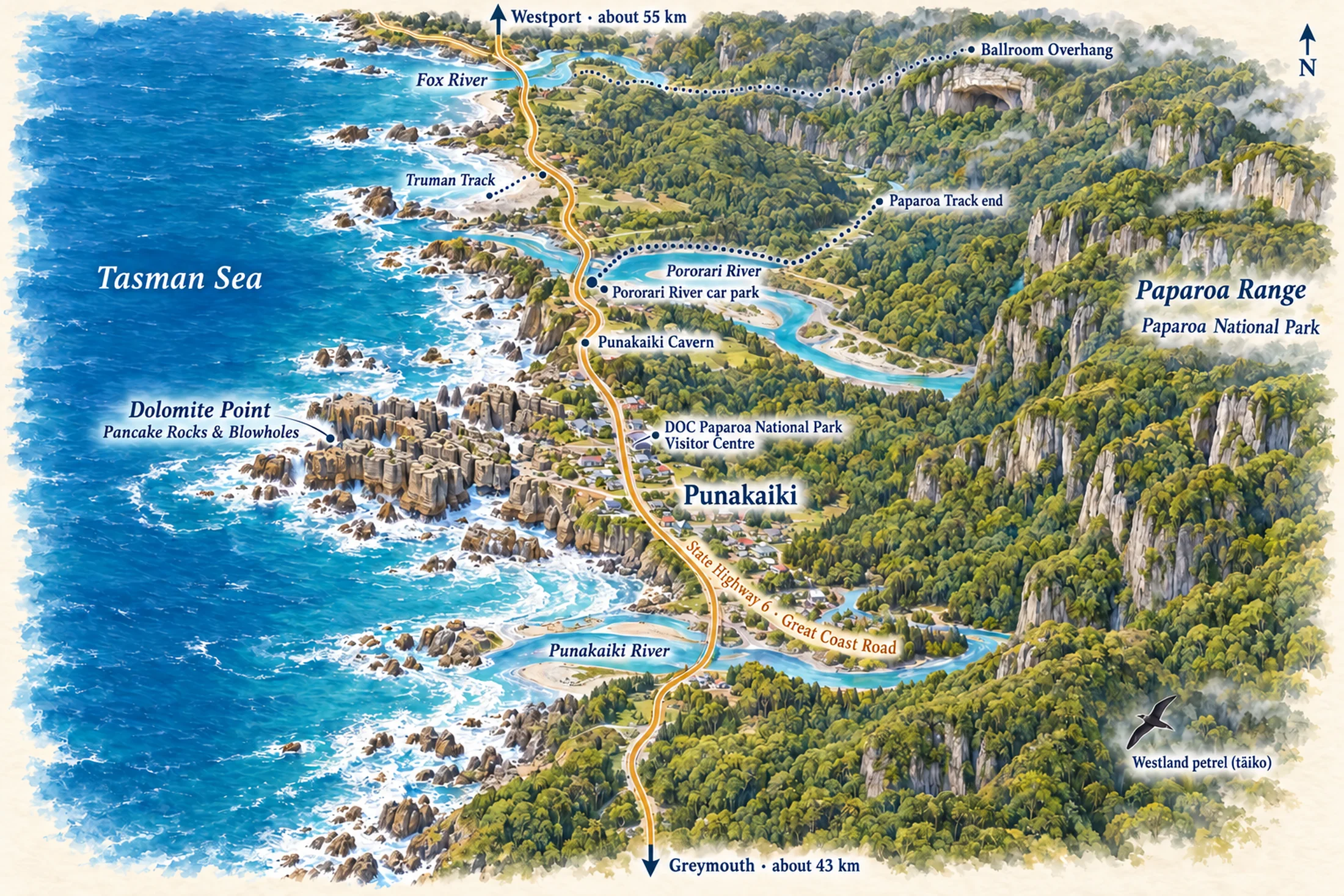
Punakaiki is one strip of road between two rivers. State Highway 6 runs along the coast with the Tasman Sea on one side and the bush-covered limestone of the Paparoa Range on the other. The Pancake Rocks are on Dolomite Point, a headland in the middle of the village, with the visitor centre, café and car park across the road. The Pororari River reaches the sea just to the north, and the Punakaiki River just to the south.
The village is small enough to have no separate areas to choose between: wherever you stay, the rocks are a short walk or drive away. Truman Track and the Fox River are north of the village along the coast road; Greymouth is about 45 minutes south and Westport about an hour north.
Places you don’t want to miss
The Pancake Rocks and Blowholes
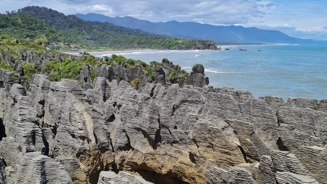
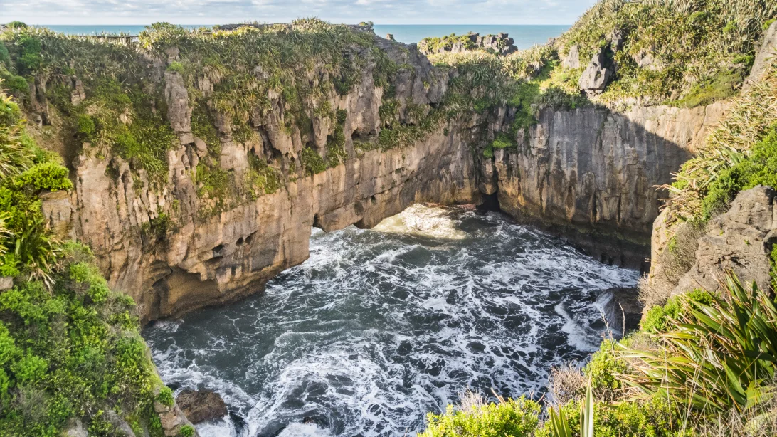
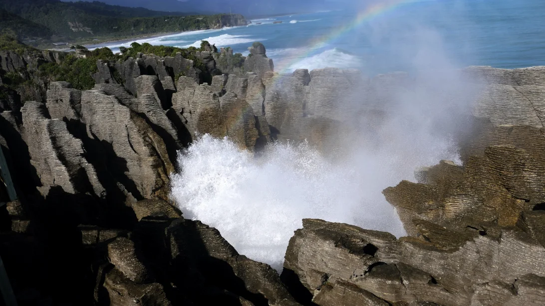
This is the reason to stop, and it deserves time. On Dolomite Point the limestone is stacked in hundreds of thin layers, grey and weathered, so that every headland, pillar and arch looks like a pile of pancakes. Between them the sea has cut chasms and surge pools, and when the swell is up it bursts through blowholes in the rock with a deep boom.
How the layers formed
The rock is limestone, made of the broken shells and skeletons of marine creatures that settled on the sea floor about 30 million years ago, by DOC’s account; GNS Science puts the rock at 22 to 30 million years old.
Over time the limestone separated into hard bands with thin, softer layers rich in mud between them. Geologists call this stylobedding, and Te Ara notes that its origin has been debated: most agree it formed after the rock was laid down, as the sediment was compacted, rather than as the original layers. Earthquakes later lifted the rock above the sea, and rain, wind and waves have been working on it since, wearing the softer layers away faster than the hard ones.
How the blowholes work, and when to see them
The sea has worked its way into caves along cracks in the limestone until some of them broke through to the surface. When a wave rushes in, it traps and squeezes the air in the cave, and water and spray are forced up through the opening.
DOC says they are at their best around high tide when there is a south-westerly swell; on a calm day at low tide they may do nothing at all. So check the tide before you go.
Toitū Te Whenua LINZ publishes the official tide tables for Westport, the nearest standard port; high water at Punakaiki will be close to Westport’s time but not the same, so the visitor centre is the place to confirm it. A marine or surf forecast will tell you whether a swell is running. We found no source for how long either side of high tide the blowholes keep going, so allow time. DOC says the rocks are at their most spectacular in the Putai area. At Sudden Sound Blowhole it has placed a lifebelt, and asks that children are kept close and on the track.
| What | Detail |
|---|---|
| The walk | A paved loop from the visitor centre across the road; DOC gives about 30 minutes, the West Coast’s tourism body 1.1 km and 20 minutes plus viewing time |
| Access | Suitable for wheelchairs with help, except for one optional section with steps (DOC) |
| When to go | Around high tide, best with a south-westerly swell; check the tide (LINZ tables for Westport) and ask at the visitor centre |
| Parking | DOC charges at the car park: $2.50 a half hour or $20 a day, by card only, with the first 10 minutes free |
| Visitor centre | Punangairi, across the road: 9am to 5pm in summer, 9am to 4pm in winter, with toilets open all hours |
| Rules | Stay on the path and behind the barriers; do not climb on the rocks. No dogs in the national park |
The walk itself is an easy loop on a paved path from the road, with lookouts over each part of the headland, and it can be walked in any weather. Allow longer than the signs suggest if the sea is putting on a show. Keep to the path: seabirds nest on the headland and rare plants grow on it. The loop comes back out onto the highway, so hold on to children at the end.
The visitor centre across the road, Punangairi, opened in November 2024. It is owned and run by Ngāti Waewae, with DOC’s Paparoa National Park visitor centre inside it, and it has a multimedia exhibition about the Paparoa. It is the place to ask about track conditions, the weather and the tide.
More to see around Punakaiki
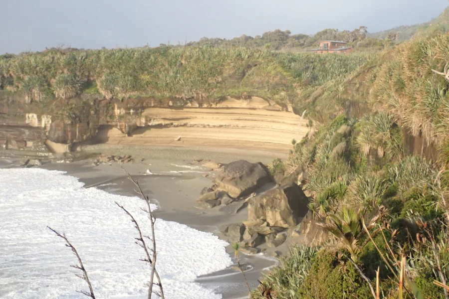
Truman Track
Fifteen minutes through coastal forest and flax to a small beach under limestone cliffs, from a car park on the coast road north of the village. DOC says the beach is safe to explore only when the tide is out, and warns of unstable cliffs and rip currents, so keep off the rocks at high tide and do not swim.
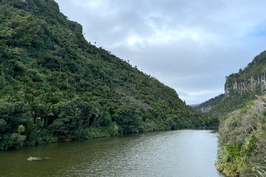
Pororari River Track
A walk up a limestone gorge just north of the village, between nikau palms and cliffs above a slow, dark river. DOC gives 3.5 km and about 45 minutes one way; walk as far as you like and come back the same way. It shares its last stretch with the Paparoa Track.
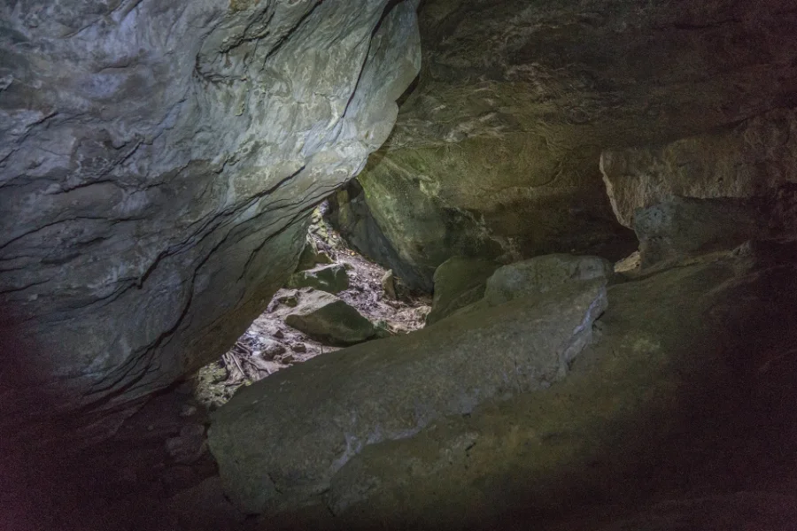
Punakaiki Cavern
A short cave beside the coast road, with about 130 m of passages and glow-worms in the dark. Bring a torch, and take care crossing the highway to reach it. It takes a few minutes, which makes it a good stop on the way in or out.
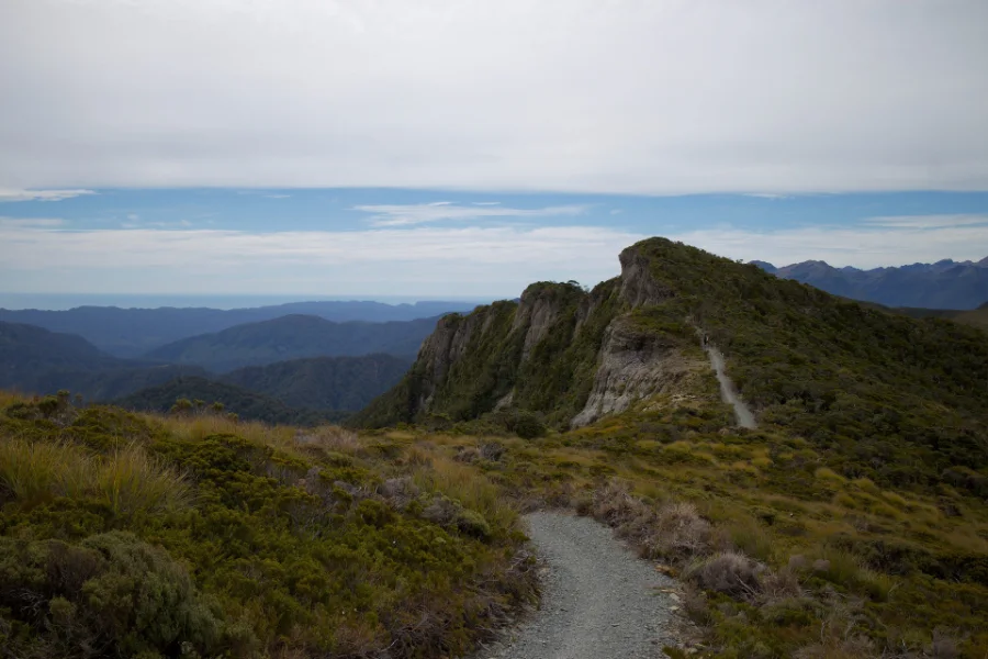
The Paparoa Track
One of New Zealand’s Great Walks, opened in 2019–2020: 55 km over the Paparoa Range from near Blackball, over three days, finishing at the Pororari River car park, 1.2 km north of the rocks. The three huts must be booked. The Pike29 Memorial Track, a side track added in 2024, leads to the site of the Pike River mine.
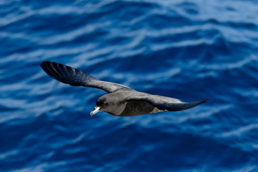
The Westland petrel colony
The Westland petrel, or tāiko, breeds in only one place in the world: the forested hills just south of the Punakaiki River. The birds fly in from the sea at dusk in the breeding season. A local operator runs guided tours to watch them arrive; we could not confirm this season’s dates, so check before you plan around it.
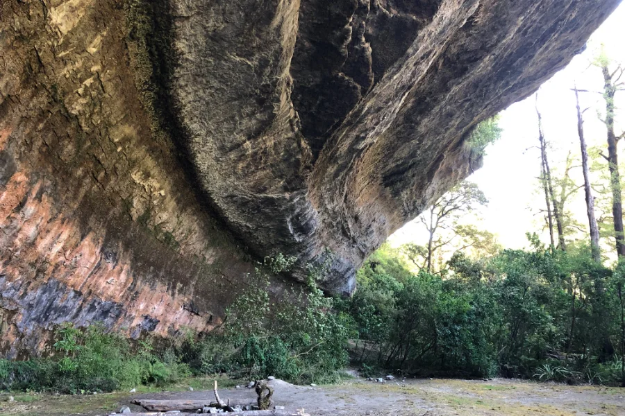
Fox River and the Ballroom Overhang
A longer half-day walk north of the village, up the Fox River to a vast overhang of limestone. DOC gives about two hours one way, with several river crossings. The river can rise quickly after rain, so go only in settled weather, and turn back if the water is high.
Go to the rocks as the tide comes in on a day with a swell, and stop at one lookout rather than hurrying round. Watch a wave come in, and see whether the spray follows it as the air in the cave below is squeezed out. Listen for the sound the rock makes as each wave arrives. Then look at the rock beside you, and run your eye along a single layer to see how far it goes.
Getting there and around
By car, Punakaiki is on State Highway 6, the coast road between Westport and Greymouth: about 45 minutes from Greymouth and an hour from Westport. It is a night on our South Island itinerary and on New Zealand in three weeks, between the north of the South Island and the glaciers; the drive on to Franz Josef is a long one. The village has no fuel, so fill up in Westport or Greymouth.
Distances: DOC gives Greymouth as 43 or 44 km and Westport as 55 or 57 km on different pages; times from InterCity’s timetable. Checked 15 October 2026.
By coach, InterCity stops in the village on its West Coast services: about 45 minutes from Greymouth, an hour from Westport, and about five hours from Franz Josef. Once you are here, the rocks, the village and the Pororari River are on foot; you need a car for Truman Track and the Fox River, or a long walk along the road.
There is no fuel in Punakaiki and only limited shopping, so fill up and stock up in Westport or Greymouth. Mobile coverage can be patchy. The coast road is exposed to slips: it was closed near Punakaiki in September 2025 and again in September 2026. Check the NZ Transport Agency on the morning you travel.
When to go
The rocks are worth seeing in any season, and in any weather; a grey day with a big swell can be better than a calm, sunny one. What matters most is the tide, so plan your visit around high tide wherever you can. This is the West Coast, and it rains often and heavily: bring a rain jacket.
Keep to the shorter walks after heavy rain, when rivers such as the Fox can rise quickly. Summer gives the longest days for the Paparoa Track and the Fox River.
Where to stay and eat
Where to stay
Places to stay are few, so book ahead, especially in summer. We name three places we could confirm, each a different kind of stay.
Scenic Hotel Punakaiki is the village’s full-service hotel, with 63 rooms by the beach and its own restaurant; its own pages put it 300 m and four minutes’ drive from the rocks, so check where your room is.
Punakaiki Rocks Hotel has nine ground-floor studios with their own bathrooms and a garden bar, about 1.1 km from the rocks by its own account. With only nine rooms, book early.
Punakaiki Beach Camp, about 700 m north of the rocks, has cabins and camping sites with a shared kitchen and hot showers; likely the cheapest of the three, though we have not compared prices, and cabin types are not listed, so ask. Checked 15 October 2026.
Two more are listed, but we could not confirm they are taking bookings: Te Nikau Retreat, cottages, lodges and backpacker beds in the bush beside the Truman Track, about 3 km north of the rocks; and Punakaiki Treehouse, studios a little further on. Contact them directly.
If the village is full, Greymouth, about 45 minutes south, and Westport, about an hour north, have the nearest wider choice of motels, as well as supermarkets. Along the coast road towards Greymouth there are a few lodges and bed and breakfasts; Breakers, at Nine Mile Creek about 14 km north of Greymouth, is one, with four sea-view rooms and its own path to the beach. Staying away from the village means driving back to the rocks for high tide, so check the tide first.
Where to eat
Choice is small, and we could not confirm closing times, so check before you rely on a late dinner. The Ocean View Restaurant at the Scenic Hotel serves breakfast and dinner with a view of the sea; lunch may be summer only, so check. The Punakaiki Rocks Hotel & Garden Bar serves lunch and dinner every day, pizza from a wood-fired oven among them; its listed hours differ between sources.
Opposite the rocks, the Pancake Rocks Café is known for its pancakes, but we could not confirm its current hours. Shopping in the village is limited, so bring food for breakfasts and picnics from Greymouth or Westport.
A final word on Punakaiki
Punakaiki is small, and it does not need to be anything more. Come for the rocks, and give them the tide they deserve; then walk a little way up the Pororari or down to the beach on the Truman Track. A night here turns a quick stop on the coast road into the best of it: the rocks at high water, with time to spare.
Andrew + Margaret
- Visiting New Zealand Overview
- The South Island itinerary Journeys
- New Zealand in three weeks Journeys
- Franz Josef & the Glacier Country Overview
- Getting around New Zealand Practical
- Best time to visit New Zealand Practical
- The TranzAlpine Journeys
- Department of Conservation — Pancake Rocks and Blowholes Official
- Department of Conservation — Paparoa Track Booking
- The West Coast’s official tourism site Official
- NZ Transport Agency — journey planner Safety
- Te Ara — the Pancake Rocks and stylobedding Culture
- Toitū Te Whenua LINZ — tide predictions Safety
How long do you need at the Pancake Rocks?
The loop takes about half an hour, but allow an hour if the blowholes are working or you want to stop at every lookout.
When do the blowholes work best?
Around high tide, with a swell from the south-west, according to DOC. At low tide on a calm day they may be quiet, so check a tide table before you go.
Is Punakaiki worth an overnight stop?
Yes, if you are driving the coast road: a night gives you a better chance of being at the rocks when a high tide falls in daylight, and time for a walk into the national park without rushing. Not every day has a daylight high tide, so check the times.