Maungawhau / Mount Eden
Maungawhau is the highest natural point on the Auckland isthmus, the crater of a volcano that stopped erupting about 28,000 years ago, and the terraced remains of a pā built for thousands of people around 1200 AD. The City Rail Link put a railway station at the bottom of it on 13 September 2026. What nobody quite says out loud is that the station is 1.8 km and about 126 vertical metres below the summit — so it is three stops and nine minutes from Waitematā, and then a half-hour walk uphill, and the walk is the best part.
Last updated 13 September 2026
Why it matters
The thing most descriptions of Maungawhau leave out is who owns it. In 2014, thirteen mana whenua iwi and hapū of Tāmaki Makaurau settled historic Treaty of Waitangi breaches with the Crown and got back fourteen tūpuna maunga — the ancestral mountains of Auckland. The Ngā Mana Whenua o Tāmaki Makaurau Collective Redress Act passed that July, and the maunga are now held in trust for those thirteen iwi and hapū and the other people of Auckland. They remain public reserves under the Reserves Act 1977, and the Authority's own wording is that they are held in trust for the common benefit of those iwi and hapū and of the other people of Auckland.
It is run by the Tūpuna Maunga Authority, a statutory body with equal membership from Ngā Mana Whenua o Tāmaki Makaurau and Auckland Council. It is independent of the Council and has its own decision-making powers; the Council does the routine work under its direction. And the Authority's first act here is the one visitors notice: in January 2016 the summit road and the tihi were permanently closed to private motor vehicles, motorbikes and scooters included, and Maungawhau became the first of the fourteen to be returned to pedestrian space. A road to the top had existed since 1869, so about a century and a half of driving up ended in a single decision. What it bought is what you now walk on.
What the closure protects is not the view. It is the pā. The Authority describes Maungawhau as “an enormous Māori pā (citadel) built for thousands of inhabitants”, and its evidence is still in the shape of the hill: flat terraces cut into the outer slopes for living and working, storage pits dug into the terraces and around the crater rim, and a line of strongpoints along the highest crest. There is one oddity, and the Authority flags it — no sign of ditch or bank defences at all, which is unusual for a heavily defended pā site.
Some of it has gone. The Authority names quarrying and the building of roads, car parks and water reservoirs, and some of that quarrying was done by inmates of the nearby prison, cutting scoria for Auckland's road-making in the early twentieth century. What survives is why the boardwalk exists: it opened in August 2020, was extended over the tihi and crater rim in June 2023, and it threads deliberately through the terraces and storage pits so that the visitors — over a million a year before Covid, on the Authority's own count — can cross them without wearing them away. Ngā Tūpuna Maunga are on a tentative list for UNESCO World Heritage status, and demonstrating that this sort of thing is properly looked after is a large part of that case.
What it's like
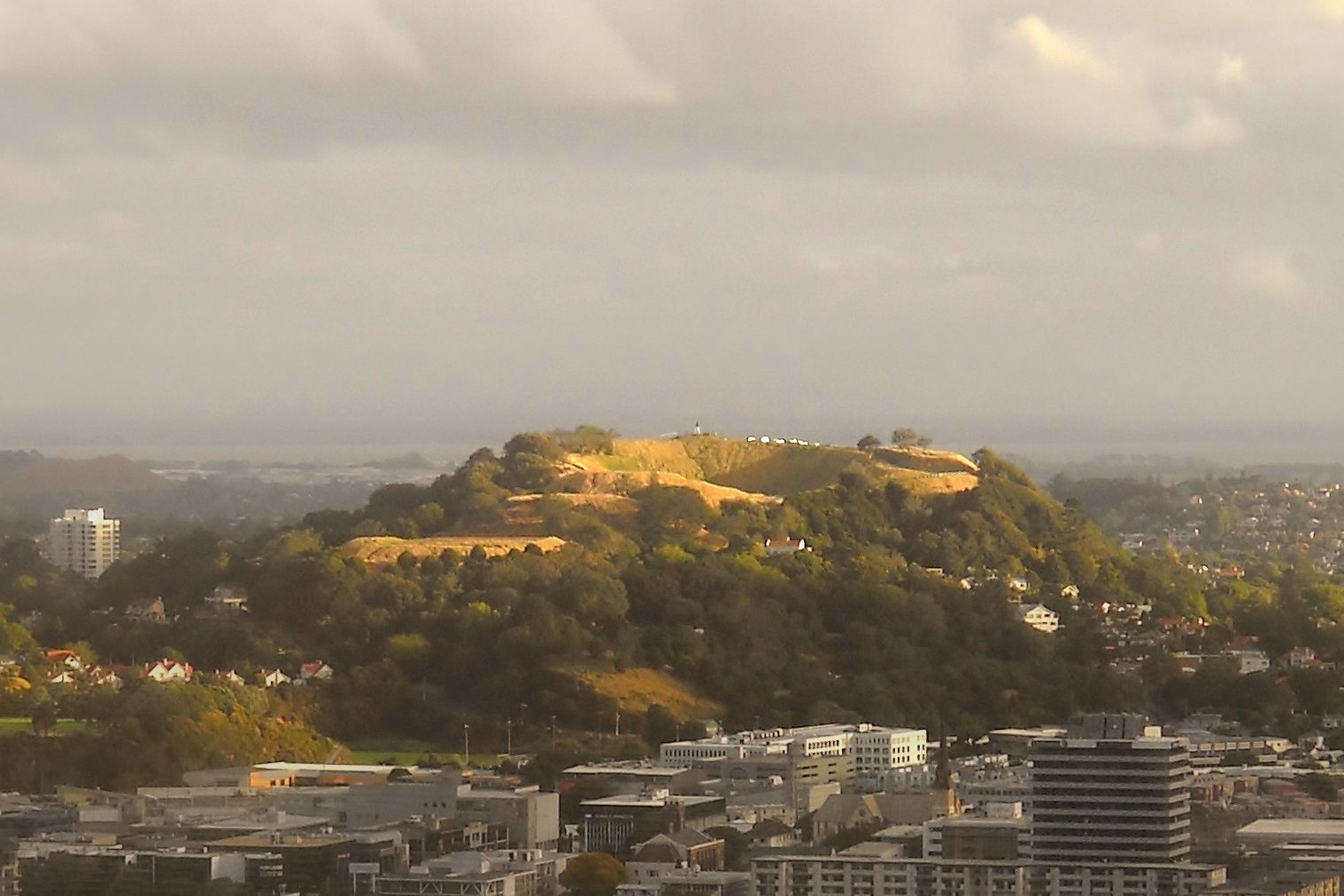
From the city centre it looks like one green cone in the middle of the suburbs, as the photograph below has it. It is two overlapping cones that erupted in quick succession; the older northern one had its crater filled by scoria from the second eruption, and the southern cone is the younger and taller of the two. Its crater is the one you come to see, 180 metres across and 50 metres deep, dropping away below the rim path.
The crater has a name, and the Tūpuna Maunga Authority gives it as Te Kapua kai a Mataoho — the food bowl of Mataoho, the atua responsible for volcanic activity. Other sources render both the crater's name and the atua's slightly differently, and we have followed the Authority's spelling as the owner's.
Stop at the station entrance before you start walking. There is water coming down the wall beside you — eight panels of it, five to nine metres high, with recycled basalt inserts and fifty-three small glass triangles, one for each volcanic cone in Tāmaki Makaurau. It was built to run continuously, to greet people and wish them safe travels, and it is there for Mataaoho, the atua of these volcanic fields. Now look up the road at the hill you are about to climb, and note what its crater is called. A railway station finished in 2026 and a pā that was already old in 1740 are naming the same atua, 1.8 km and a hundred and twenty-six vertical metres apart.
How to visit
Take the train and walk up. Maungawhau Station is 9 minutes from Waitematā and 6 from Te Waihorotiu, and from its Ruru Street entrance it is 1.8 km and about 126 metres of climb to the tihi.
The gate hours are the thing to plan around: 7am to 8.30pm in summer, 7am to 7pm in winter, shifting with daylight saving.
By train. The station has four platforms and two lines. Platforms 1 and 2 are the East West line — 1 towards the city via Karanga-a-Hape, 2 west to Kingsland. Platforms 3 and 4 are the Onehunga West line — 3 towards the city via Grafton, 4 to either Grafton or Kingsland. The East West runs every 15 minutes off peak and about every 10 at peak; the Onehunga West every 30. Because trains from here go several ways, check the destination on the front of the train and on the platform screens before you board — Auckland Transport says so itself. Our page on getting around Auckland has the fares and the two caps.
The walk, and the distinction nobody else draws. Auckland Transport calls the station “an easy walk to the Maungawhau / Mount Eden volcanic cone”, and that is perfectly fair for reaching the park — Tahaki Reserve, where the old tea kiosk, the education centre and the café are, is about three-quarters of a kilometre from the station as the crow flies, and sits below most of the climb. It is not a description of reaching the summit. For the tihi, allow about half an hour up as a rule of thumb for 1.8 km with that much ascent, and about twenty-five minutes back down. The boardwalk takes over for the terraces, the tihi and the crater rim; the approach below it is uphill throughout, so wear something you can walk in.
By bus. From Mount Eden Road, the 25B, 25L, 27H and 27W run to the city centre and the 64 to Newmarket. From New North Road, the 22N, 22R, 24B and 24R run to Victoria Park.
By car, which needs saying carefully. You can drive to Maungawhau. You cannot drive up it. The Authority keeps four visitor car parks around the base — two by the Puhi Huia Road roundabout, one in Tahaki Reserve below the old tea kiosk, one at the Normanby Road playground — with time limits enforced. Street parking near the station is paid Monday to Friday, 8am to 6pm, at NZ$1 an hour for two hours and NZ$2 an hour after that, and Auckland Transport has consulted on a new plan for those streets whose outcome was still unpublished when we checked. Public toilets are by the Puhi Huia Road roundabout and at the Normanby Road playground.
Dogs are welcome on a leash and under control, but not in the playground. The only off-leash areas are the fenced paddock by the Clive Road car park and the fenced area in Tahaki Reserve.
Two things we could not settle, and you should check before you go. The Authority has been stabilising the old Batger Quarry retaining wall on the south-western flank; its notice said the work would start in late April or early May 2026 and take two to three months, and no completion notice has been published. Throughout it, the Authority's commitment is explicit — the maunga and the tihi stay open — but “the walking track below the quarry wall may also need to be closed at times”, so follow the signs on the ground. Separately, the maunga closes in the evenings around Guy Fawkes, because fireworks have started fires here before: in 2025 all fourteen tūpuna maunga shut from 6.30pm to 7am between 2 and 5 November. The 2026 dates had not been published when we checked.
Te Ipu Kōrero o Maungawhau, the education centre in the old kiosk, has a short film and an augmented-reality model of the maunga, and Friend Whau café shares the building. Neither publishes its opening hours, so treat both as a bonus rather than a plan. We also could not find any published statement on step-free or mobility access to the tihi; the boardwalk extension is described as running from the car park, but we would rather send you to the Authority than guess.
Making the most of it
Walk the crater rim, do not just look into it. The tihi has the lookout and the view, and the storage pits that make this a pā rather than a hill are along the rim path. The Authority describes them as pits dug into the terraces and around the crater rim, and says they can still be picked out from the rim track.
Stay on the boardwalk, and know why you are being asked to. Before it was built, the dirt tracks and the rim were rutting badly and the erosion was taking the terraces with it. The boardwalk was designed after its makers looked at Yosemite and at the paths around Stonehenge, it is laid on the contours to keep it low, and it is built so that air, water and light still reach the ground underneath. It carries a large tea-gathering space, and the Authority describes its platforms and seating as offering uninterrupted views from the harbours to the other tūpuna maunga — the one part of the boardwalk built to be sat on rather than walked over.
Come early, or come late. The gate opens at 7am year-round and shuts at 8.30pm in summer or 7pm in winter, which gives you a long day at both ends of it. Expect company in the middle of the day.
The station and the car parks come at the maunga from different sides. The four car parks are spread around the base — two by the Puhi Huia Road roundabout, one in Tahaki Reserve, one at the Normanby Road playground — so whichever you use, it is the same climb approached from a different flank. Arriving by train adds the 1.8 km approach in front of it.
Nearby
Eden Garden is not the maunga's park, and the names catch people out. It is a separate botanic garden on the flank of the maunga, run as a charitable organisation, open 9am to 4pm, and it charges — NZ$12 for adults, NZ$8 for New Zealand seniors and students, free for children under 12. It is worth an hour if you like plants, but it is not where you go for the crater, and the maunga itself never costs anything.
The other maunga are the real follow-on. Maungakiekie / One Tree Hill is where Kiwi Tāmaki moved Waiohua's seat of power from Maungawhau in the eighteenth century, so the two hills are one story in the wrong order. Devonport has two more, Takarunga and Maungauika, and gets you there by ferry with the same summit-road rule in force.
One stop west on the East West line is Kingsland, if you want to carry on rather than double back. The Auckland War Memorial Museum is the indoor companion to all of this — the maunga shows you the pā from outside, the museum explains it. And Auckland itself sets out how the rest of the city fits around its volcanoes.
A final word on Maungawhau
Go up it on foot. The train makes that easy in a way it never was before, but the thirty minutes between the platform and the crater rim are not an obstacle between you and the view — they are the reason the view means anything when you get there, and they are the reason the terraces are still in the hillside to be walked past on the way.
Andrew + Margaret
- Auckland Overview
- Getting around Auckland Practical
- Devonport Overview
- Auckland War Memorial Museum Culture
- Piha and the west coast Overview
- Day trips from Auckland Overview
- Tūpuna Maunga Authority on Maungawhau Official
- The Authority's notices and closures Official
- The 2014 Treaty settlement Culture
- Auckland Transport on Maungawhau Station Official
- Eden Garden Booking
Can I drive to the top of Maungawhau?
No. The summit road and the tihi have been closed to private vehicles — cars, motorbikes and scooters — since January 2016, and the closure is permanent. You can still drive to the base and park in one of four car parks; the climb is on foot from there.
Is the station really at the bottom of the mountain?
Close, but not at the foot of the climb. Maungawhau Station is 1.8 km from the summit with about 126 metres of ascent in between, so allow around half an hour on foot. Tahaki Reserve, with the kiosk and the café, is appreciably nearer and lower if you only want the park.
Why is everything here called Mount Eden?
The maunga, the suburb, the road and a prison all carry the name, which commemorates George Eden, Earl of Auckland, and not anything about the place itself. The station used to as well — it was rebuilt on the same site and renamed Maungawhau when the City Rail Link opened. Eden Garden, on the flank, is a separate paid garden, and Eden Terrace is the neighbourhood the station actually serves.
How long do I need?
About an hour and a half door to door from the station, which is half an hour up, twenty-five minutes down and half an hour at the top. Add an hour if you want the education centre, the café and the full crater rim rather than the lookout.
Does it cost anything?
No. Maungawhau is a public reserve and free to enter, as all fourteen tūpuna maunga are. The only things to pay for nearby are Eden Garden and whatever the kiosk café is serving when it is open.